• chevron_right

      Early plate tectonics was surprisingly speedy

      news.movim.eu / ArsTechnica · Wednesday, 16 August, 2023 - 15:30 · 1 minute

    Image of a small person standing in front of large, reddish rocks.

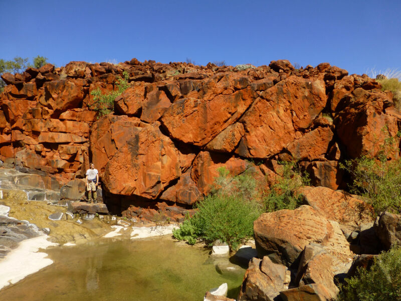
    Enlarge / 2.7-billion-year-old basalt lava flows in the Pilbara Craton, now tilted about 45 degrees from horizontal. (credit: Jennifer Kasbohm )

    Have tectonic plates changed speed over the last three billion years? The answer has far-reaching implications, as plate tectonics affected everything from the supply of vital nutrients for early life to the rise of oxygen . We know Earth’s interior was hotter early in its history, but did plates move faster because the hotter mantle was squishier, or did the hotter mantle contain less water , which helps mantle minerals flow, slowing plates down?

    A new study , led by Dr. Jennifer Kasbohm of Yale, measured ancient magnetic fields and dated rocks from Western Australia to show that the “Pilbara Craton”—an early continent—moved at quite a clip around 2.7 billion years ago. While today’s fastest plate motion is around 12 cm (4.7 in) per year, the Pilbara Craton moved as much as 64 centimeters (25 inches) per year.

    A rare remnant of early Earth

    In the Archean eon, a time far closer to the formation of our Solar System than to today, basalt oozed over what would later be Western Australia in much the same way it does in Iceland and Hawaii today. Plate tectonics was still relatively new , and continents were in the early stages of emerging from what had largely been a water world . The air was devoid of oxygen, and the most advanced life came in the form of microbial communities that are preserved today in hummocky fossils known as “ stromatolites .”

    Read 29 remaining paragraphs | Comments

    • chevron_right

      Has the century-old mystery of Antarctica’s “Blood Falls” finally been solved?

      news.movim.eu / ArsTechnica · Wednesday, 12 July, 2023 - 17:07 · 1 minute

    Blood Falls seeps from the end of the Taylor Glacier into Lake Bonney

    Enlarge / Blood Falls seeps from the end of the Taylor Glacier into Lake Bonney. Scientists believe a buried saltwater reservoir is partly responsible for the discoloration, which is a form of reduced iron. (credit: NSF/Peter Rejcek/Public domain)

    In 1911, an Australian geologist named Thomas Griffith Taylor was exploring a valley in Antarctica when he stumbled upon a strange waterfall. The meltwater flowing from beneath the glacier that now bears Taylor's name turns a deep red upon coming into contact with the air, earning the site the moniker "Blood Falls." Various hypotheses have been proposed over the last century to explain the strange phenomenon. A team of scientists now thinks they've finally found the answer: tiny nanospheres rich in iron, silica, calcium, aluminum, and sodium, among other elements.

    But why has solving this mystery taken more than a century? It seems the nanospheres are amorphous materials, meaning they lack a crystalline structure and hence eluded prior analytical methods looking for minerals because they are not, technically, minerals, according to a recent paper published in the journal Frontiers in Astronomy and Space Science. That might seem like an odd choice of journal for this study, but the Blood Falls at Taylor Glacier is a so-called "analogue" site for astrobiologists and planetary scientists keen to learn more about how life might evolve and thrive in similar inhospitable environments elsewhere in the universe.

    "With the advent of the Mars Rover missions, there was an interest in trying to analyze the solids that came out of the waters of Blood Falls as if it was a Martian landing site," said co-author Ken Livi of Johns Hopkins University. "What would happen if a Mars Rover landed in Antarctica? Would it be able to determine what was causing the Blood Falls to be red? It's a fascinating question and one that several researchers were considering."

    Read 8 remaining paragraphs | Comments

    • chevron_right

      Massive peak collapses may reshape Himalayas

      news.movim.eu / ArsTechnica · Wednesday, 5 July, 2023 - 19:39

    Image of a series of snow-covered peaks.

    Enlarge / Annapurna IV, at left here, might have once been half a kilometer taller. (credit: Richard I'Anson )

    The Earth's mountains are engaged in a constant balancing act. Tectonic forces—a combination of volcanism and plate collisions—push them skyward. But erosion pulls them down. The height of the tallest peaks is set by which of these forces dominate.

    When it comes to erosion, ice can be a dominant factor. Glaciers scrape away rock, while freeze/thaw cycles crack it. But a new paper suggests that ice has a limited effect on the very tallest peaks. At those altitudes, the freeze/thaw cycle shuts down because things remain cold year-round. And most peaks are steep enough that glaciers never have the chance to form. (They're mostly a kilometer or more below the peaks, down in the valleys).

    Instead, the new paper argues that the tallest mountains don't so much erode as collapse, producing utterly massive landslides that can be catastrophic many miles downslope. To make this case, the paper presents evidence from a landslide involving 20 cubic kilometers of material in the Annapurna region of Nepal.

    Read 14 remaining paragraphs | Comments

    • chevron_right

      Nuclear Waste Borehole Demonstration Center started

      news.movim.eu / ArsTechnica · Friday, 17 March, 2023 - 17:44 · 1 minute

    A diagram of what a waste borehole might look like, with various additional objects included for scale.

    Enlarge / An artist’s impression of a deep borehole for nuclear waste disposal by Sandia National Laboratories in 2012. Red lines show the depth of mined repositories: Onkalo is the Finnish one, and WIPP is the US DOE repository for defense waste in New Mexico. (credit: Sandia National Laboratories)

    Deep Isolation , a company founded in 2016 and headquartered in California, launched a “ Deep Borehole Demonstration Center ” on February 27. It aims to show that disposal of nuclear waste in deep boreholes is a safe and practical alternative to the mined tunnels that make up most of today’s designs for nuclear waste repositories.

    But while the launch named initial board members and published a high-level plan, the startup doesn’t yet have a permanent location, nor does it have the funds secured to complete its planned drilling and testing program.

    Although the idea to use deep boreholes for nuclear waste disposal isn’t new , nobody has yet demonstrated it works. The Deep Borehole Demonstration Center aims to be an end-to-end demonstration at full scale, testing everything: safe handling of waste canisters at the surface, disposal, possible retrieval, and eventual permanent sealing deep underground. It will also rehearse techniques for ensuring that eventual underground leaks will not contaminate the surface environment, even many millennia after disposal.

    Read 23 remaining paragraphs | Comments

    • chevron_right

      All the ways the most common bit of climate misinformation is wrong

      news.movim.eu / ArsTechnica · Wednesday, 15 March, 2023 - 11:00

    Is it natural, or is it us? (It's us.)

    Enlarge / Is it natural, or is it us? (It's us.) (credit: Andriy Onufriyenko/Getty Images)

    It starts as a reasonable question: If the Earth's climate changed before humans existed, how can we be so sure the current change is due to us and not something natural?

    To answer that question, we need to understand what caused the natural changes of the past. Fortunately, science has a good handle on the causes of Earth’s natural climate changes going back hundreds of millions of years. Some were cyclical; others were gradual shifts or abrupt events, but none explain our changing climate today.

    A zombie claim

    With energy policy and elections in the news, the claim by some politicians that climate change is natural is once again bubbling up from the disinformation swamp. So I asked some scientists a very unscientific question: What would they buy if they had a dollar for every time they heard it?

    Read 53 remaining paragraphs | Comments

    • chevron_right

      This Yellowstone hot spring’s rhythmic thump makes it a geo-thermometer

      news.movim.eu / ArsTechnica · Friday, 10 March, 2023 - 19:23 · 1 minute

    The vibrating water surface of Doublet Pool in Yellowstone National Park. Credit: Jamie Farrell/University of Utah

    Yellowstone National Park is most famous for Old Faithful , a geyser with fairly predictable periodic eruptions that delight visiting tourists. But it's also home to many other geothermal features like Doublet Pool , a pair of hot springs connected by a small neck with the geothermic equivalent of a pulse. The pool "thumps" every 20-30 minutes, causing the water to vibrate and the ground to shake. Researchers at the University of Utah have measured those thumping cycles with seismometers to learn more about how they change over time. Among other findings, they discovered that the intervals of silence between thumps correlate with how much heat is flowing into the pool, according to a new paper published in the journal Geophysical Research Letters.

    “We knew Doublet Pool thumps every 20-30 minutes,” said co-author Fan-Chi Lin , a geophysicist at the University of Utah. “But there was not much previous knowledge on what controls the variation. In fact, I don’t think many people actually realize the thumping interval varies. People pay more attention to geysers.”

    Yellowstone's elaborate hydrothermal system is the result of shallow groundwater interacting with heat from a hot magma chamber. The system boasts some 10,000 geothermal features, including steam vents (fumaroles), mud pots, and travertine terraces (chalky white rock), as well as geysers and hot springs.

    Read 7 remaining paragraphs | Comments

    • chevron_right

      Earth’s long-term climate controlled by just 12% of the landscape

      news.movim.eu / ArsTechnica · Monday, 13 February, 2023 - 15:37 · 1 minute

    Image of the face of a thin sheet of rock, showing grey and iridescent sections.

    Enlarge / A slice through a crystal of Feldspar (gray, center of view), a key mineral in the weathering process. (credit: Chmee2/Wikimedia CC-by-SA)

    Scientists have understood for years that silicate minerals react with CO 2 and water to remove CO 2 from the atmosphere, acting as a thermostat that kept Earth’s climate broadly stable over billions of years. But how sensitive is that thermostat? To find out, scientists need to scale up lab measurements to fit the real world, but it has been impossible to reconcile the lab work with the real-world measurements made in soils and rivers.

    This gap in our understanding has hampered efforts to model Earth’s long-term carbon cycle and climate, making it hard to predict exactly how effective silicate weathering, both natural and artificial, would be at removing CO 2 from our atmosphere.

    In a paper in the journal Science , professor Susan Brantley and her team from Penn State University have found a way to quantify silicate weathering’s response to temperature consistently at all scales, from lab measurements and real-world measurements in landscapes to the whole world. In doing so, they have identified the kind of landscape that has the most influence on Earth’s thermostat.

    Read 23 remaining paragraphs | Comments

    • chevron_right

      How the world of the end-Triassic extinction was similar to today—and how it differed

      news.movim.eu / ArsTechnica · Wednesday, 8 February, 2023 - 12:30 · 1 minute

    How the world of the end-Triassic extinction was similar to today—and how it differed

    Enlarge (credit: Victor Leshyk)

    The end-Triassic extinction, which happened 201 million years ago, was Earth’s third most severe extinction event since the dawn of animal life. Like today, CO 2 rise and global warming were present, but the similarities don’t end there. As with today, it was a time of wildfires, deforestation, downpours, erosion, ocean acidification, marine dead zones, vanishing coral reefs, sea-level rise, and even insect plagues. There was also pollution by mercury, sulfur dioxide, halocarbons, and methane —and possibly even a damaged ozone layer.

    “Something very violent occurred 201 million years ago, with great similarity in terms of CO 2 with what we see is happening now,” said Dr. Manfredo Capriolo of the University of Oslo. That would seem to make it a good model to understand what’s going on now. But there are glaring differences—most notably the lack of humans.

    Instead of the human pollution of today, the end-Triassic saw massive volcanic eruptions that emitted prodigious amounts of greenhouse gases and pollutants. There were other differences as well. During the Triassic, there was just one continent, called “Pangea,” and the climate started warmer and ice-free, with CO 2 levels much higher than those of today. Dinosaurs had yet to dominate the planet, and there was no grass or flowers.

    Read 51 remaining paragraphs | Comments

    • chevron_right

      Fire of Love revisits tragedy of French volcanologists who died in 1991

      news.movim.eu / ArsTechnica · Tuesday, 17 January, 2023 - 20:21 · 1 minute

    Vulcanologist Katia Krafft stands near a lava burst

    Enlarge / Volcanologist Katia Krafft wears a heat suit for protection from an erupting volcano in Fire of Love . (credit: Image'Est)

    French volcanologists Maurice and Katia Krafft carved out an illustrious career by daring to go where most of their colleagues feared to tread: right to the edge of an erupting volcano. The photographs and video footage they recorded during the 1970s and 1980s contributed to significant breakthroughs in their chosen field. Alas, the couple's luck ran out on June 3, 1991, when they were killed by a massive pyroclastic flow from the eruption of Mount Unzen in Japan. The striking image above of Katia Krafft in a protective heat suit, dwarfed by a wall of fire, is just one of many powerful moments featured in Fire of Love , a 2022 National Geographic documentary about this extraordinary couple that is now streaming on Disney+.

    Director Sara Dosa was scouring archival images of volcano imagery for one of the segments in her previous documentary ( The Seer and the Unseen ) set in Iceland when she came across the story of the Kraffts. "I became completely hooked on the nature of their relationship," she recalled. "It wasn't just Maurice and Katia in a relationship; it was almost a love triangle between the two of them and the volcanoes." Apart from a handful of new footage shot by cinematographer Pablo Alvarez-Mesa, the entire film is composed of archival footage.

    Maurice and Katia (nee Conrad) Krafft met at the University of Strasbourg and married in 1970. Katia earned degrees in physics and chemistry, while Maurice studied geology. He had been fascinated by volcanoes since he was 7 years old during a family trip to Naples and Stromboli. Katia shared that fascination, and one of their first excursions as a couple was to Stromboli, where they photographed its eruption.

    Read 15 remaining paragraphs | Comments