• chevron_right

      We’ve reached the end of a bizarre Atlantic hurricane season

      news.movim.eu / ArsTechnica · Monday, 28 November, 2022 - 15:54

    Hurricane Ian, as seen from the International Space Station.

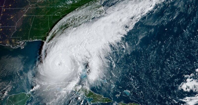
    Enlarge / Hurricane Ian, as seen from the International Space Station. (credit: NASA)

    The Atlantic hurricane season officially ends on Wednesday, bringing to a close the six-month period when the vast majority of tropical activity occurs in the Atlantic Ocean, Gulf of Mexico, and Caribbean Sea.

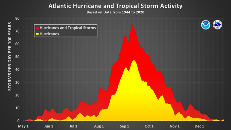
    Prior to the season, forecasters generally expected a busier-than-normal season. However, six months later, overall activity this year has come in slightly below normal. One of the more scientifically rigorous measurements of seasonal activity—based on the length and intensity of storms—is Accumulated Cyclone Energy. This year's value, 95, is about three-quarters of the normal value of 126.

    That bland statistic belies the fact that this was an odd season. After three weak early-season storms, the Atlantic basin produced zero named storms between July 3 and August 31. This was the first time since 1941 that the Atlantic had no named storm activity during this period. Then, a light came on. Four hurricanes formed in September, along with three more in November. This brought seasonal activity to near-normal levels.

    Read 11 remaining paragraphs | Comments

    • chevron_right

      After 23 years, Weather Channel’s iconic computerized channel is shutting down

      news.movim.eu / ArsTechnica · Friday, 7 October, 2022 - 20:16 · 1 minute

    An on-air capture of Weatherscan in 2020.

    Enlarge / An on-air capture of Weatherscan in 2020. Weatherscan shows 24/7 weather forecasts controlled by computer. (credit: TWC Archive )

    In the early 2000s, Americans who wanted to catch the local weather forecast at any time might turn on their TV and switch over to Weatherscan, a 24-hour computer-controlled weather forecast channel with a relaxing smooth jazz soundtrack. After 23 years, The Weather Channel announced that Weatherscan will be shutting down permanently on or before December 9. But a group of die-hard fans will not let it go quietly into the night.

    Launched in 1999, Weatherscan currently appears in a dwindling number of local American cable TV and satellite markets. It shows automated local weather information on a loop, generated by an Intellistar computer system installed locally for each market. Declining viewership and the ubiquity of smartphone weather apps are the primary reasons it's going offline.

    There are also technical issues with maintaining the hardware behind the service. "Weatherscan has been dying a slow death over the course of the last 10 years because the hardware is aging," says Mike Bates, a tech hobbyist who collects and restores Weather Channel computer hardware as part of a group of die-hard fans who follow insider news from the company. "It's 20 years old now, and more and more cable companies have been pulling the service."

    Read 8 remaining paragraphs | Comments

    • chevron_right

      As a meteorologist, Hurricane Ian is the nightmare storm I worry about most

      news.movim.eu / ArsTechnica · Wednesday, 28 September, 2022 - 13:34

    A satellite image of Hurricane Ian as of 7:50 am ET on Wednesday.

    Enlarge / A satellite image of Hurricane Ian as of 7:50 am ET on Wednesday. (credit: NOAA)

    I have lived near the Texas coast for two decades and written about hurricanes professionally for nearly as long. When you do that, you think a lot about what would become of your home should the worst happen.

    Well, the worst is happening in Southwest Florida today.

    Hurricane Ian has undergone a remarkable period of intensification during the last 24 hours. After crossing the western end of Cuba and knocking that island nation's power grid offline, Ian started to weaken a bit Tuesday following this brief interaction with land. It also underwent an "eyewall replacement cycle," in which the centermost bands of the storm contract and are replaced by a new ring of storms farther out. Often this process temporarily weakens a storm, but Ian was hardly fazed.

    Read 10 remaining paragraphs | Comments

    • chevron_right

      This should be the absolute peak of hurricane season—but it’s dead quiet out there

      news.movim.eu / ArsTechnica · Sunday, 11 September, 2022 - 14:01

    The Atlantic hurricane season peaks on September 10.

    Enlarge / The Atlantic hurricane season peaks on September 10. (credit: NOAA)

    To state the obvious: This has been an unorthodox Atlantic hurricane season.

    Everyone from the US agency devoted to studying weather, oceans, and the atmosphere—the National Ocean and Atmospheric Administration—to the most highly regarded hurricane professionals predicted a season with above-normal to well above-normal activity.

    For example, NOAA’s outlook for the 2022 Atlantic hurricane season, which runs from June 1 to November 30, predicted a 65 percent chance of an above-normal season, a 25 percent chance of a near-normal season and a 10 percent chance of a below-normal season. The primary factor behind these predictions was an expectation that La Niña would persist in the Pacific Ocean, leading to atmospheric conditions in the tropical Atlantic more favorable to storm formation and intensification. La Niña has persisted, but the storms still have not come in bunches.

    Read 9 remaining paragraphs | Comments

    • Th chevron_right

      Melbourne poised for ‘dangerous’ peak-hour storms

      pubsub.dcentralisedmedia.com / TheNewDaily · Friday, 5 February, 2021 - 02:09 · 1 minute

    Heavy rain and gusty winds are expected to blight peak hour across Melbourne on Friday.

    Parts of Victoria and the city are expected to receive a summer soaking on Friday as a low-pressure system continues to track east.

    The deluge is likely to produce 30-60 millimetres of rain in the state’s central north and north-east, while Melbourne is tipped to post totals of up to 35 millimetres.

    The Bureau of Meteorology’s Michale Laczko said conditions were expected to ramp up in the city on Friday afternoon, as severe thunderstorms cleared in the state’s south-west.

    “The focus is now moving into central and eastern Victoria,” the senior forecaster said.

    “The forecast is still looking on track with rain and thunderstorms to intensify later this morning and into this afternoon about central and north-eastern areas.”

    Mr Laczko said drivers should be alert to potentially slippery roads on Friday afternoon.

    “People should be aware when picking up their kids and in the rush hour this afternoon and evening that storms and heavy rain may make driving conditions dangerous,” he said.

    “Please do take some extra care on the roads.”

    The bureau has issued a weather warning for roads across Melbourne.

    “Reduced visibility in heavy rain and gusty winds will make driving conditions dangerous during Friday in all suburbs,” it said.

    The thunderstorms are already whipping up wild winds, with a severe weather warning stretching from Colac to Corryong on the Victorian-NSW border.

    Peak winds of 90-100km/h have been recorded over Mount Hotham, Falls Creek and Mount Buller. Ballarat has had a 78km/h gust.

    On Thursday, SES deputy chief officer David Baker warned the system would be “challenging” for Victorians and said they should be alert.

    The wild Friday weather is due to a band of stormy weather stretching from south-west Queensland as far south as Tasmania. NSW can also expect storms and heavy rain on Friday and Saturday.

    -more to come

    -with AAP

    The post Melbourne poised for ‘dangerous’ peak-hour storms appeared first on The New Daily .